Should wealthy cities like London and Paris be the only ones that have access to the street-level air quality data needed to improve our health? How can AI help improve air quality for all?
Right now, that’s exactly what’s happening. While major cities invest £80k-150k for dispersion air quality models that can take up to 10 months to produce, smaller cities and towns are left behind. Many towns and cities had dispersion modelling done in the early days of the Local Air Quality Management (LAQM) regime, then declared Air Quality Management Areas (AQMAs), but have not had the funding to repeat the exercise. They have not had the data or funding to create tools that empower local people to understand and mitigate the risks of air quality in their communities.
At Tranquil City, we’ve just reached a new milestone with our development of bespoke AI systems, which support our Airmaps, that can model air quality at scale, and we’re excited to share it with you. We want to share how AI can be a force for good (if used with people, nature and climate in mind), sparking a conversation between environmental professionals, AI researchers, local authority leaders and the public.
Air Quality Mapping Today
Air pollution claims the lives of up to 43,000 adults annually in the UK alone (Defra’s UK-Air report for 2024). Yet access to locally relevant, actionable air quality models that can help raise awareness and help inform ways to improve air quality remains a luxury that only wealthy cities can afford.
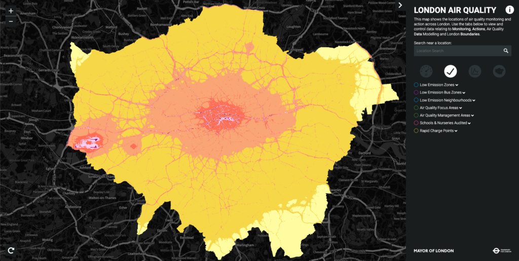
Traditional dispersion models (produced using software such as ADMS) that can model air pollution down to a street-by-street level can cost between £80k-150k for large regional areas. The modelling exercise can take up to 10 months to complete and is, at best, repeated annually due to costs. An example is the Greater London Authority air quality model shown below.
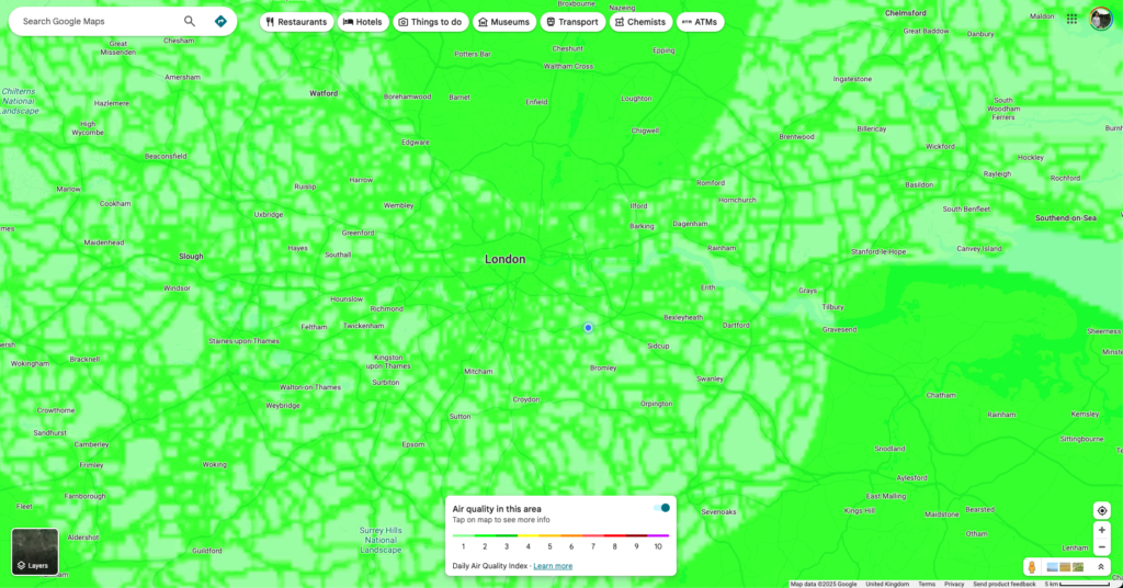
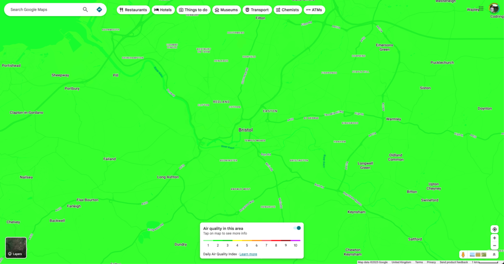
On the other hand, globally available air quality data derived from satellite models (such as Google Maps Air Quality layer) is updated hourly, but the resolution it provides is at best 350m. This resolution effectively ignores the street-by-street differences and can often show cities like London as having ‘good air quality’ across the entire city with little to no variation across it. This is wholly misleading, where any Londoner will know how pollution levels can vary drastically between their local park to the North or South Circular roads.
But how can air quality models be made more affordable, more representative of actual pollution levels street-by-street, and more able to be produced at scale? Answering this will help create a future where every town and city can provide their residents with tools to help them improve their health, as well as increase support for lasting measures that improve air quality.
This isn’t just about money—it’s about impact. Every community deserves to know which streets are safe for their children to walk to school.
How Can AI Help Close This Gap?
We’ve been developing AI-based air pollution models since 2021, with good levels of success using OpenStreetMap (OSM) informed tree-based machine learning. We processed OSM data into a hexagon grid (Uber H3) and then trained it to learn how various landuse types, road types, presence of greenery, etc, related to air pollution concentrations for Nitrogen Dioxide (NO2) and Particulate Matter 2.5 (PM2.5). But this approach had limitations due to inconsistencies in the OSM data across regions, which made it time-consuming to scale, and the fact that our tree-based models lacked a spatial awareness that was critical in mapping how air pollution disperses.
Then our Machine Learning Engineer, Matt Megarry, proposed that we could try using a Convolutional Neural Network, or CNN, model to treat air quality mapping like computer vision—because fundamentally, pollution dispersion is a visual pattern problem. Just as CNNs excel at recognising how objects in images relate spatially, they’re naturally suited to understanding how pollution from a busy road disperses through nearby residential streets, or how a park acts as a natural buffer. We then embarked on an R&D programme from feasibility to proof-of-concept that has produced a new model that significantly improves accuracy, speed and scalability of our air quality data products.
What are the features of our model?:
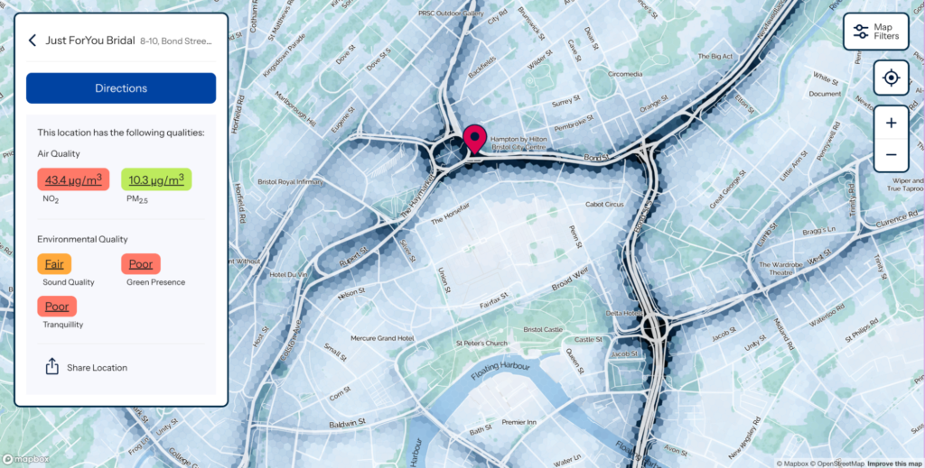
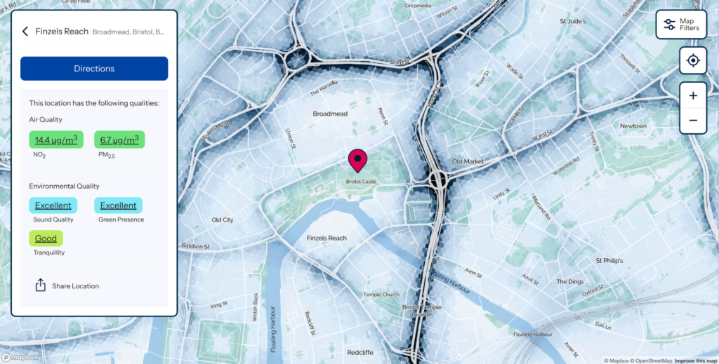
- High-Resolution: 10m resolution showing street-to-street differences. Enough to predict the difference between you and your neighbour and help choose healthier journeys.
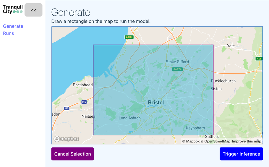
- Predictions in minutes: The CNN model inference web-app gathers the input data and produces outputs for regions the size of Bristol in 4-6 minutes.
- Training data: London Atmospheric Emissions Inventory (LAEI)—high-quality atmospheric modelling predictions using ADMS by Imperial College London (open data by GLA)
- Inputs: Customised Map tile images + Copernicus satellite data (both freely available) + local sensor/diffusion tube monitoring (for verification)
- Output: LAEI-quality predictions for any UK location
Here’s a sneak preview of how our internal modelling web-application can produce a city-wide air quality model in a matter of minutes – producing outputs that are <8 µg/m3 Root Mean Square Error (RMSE) compared to local monitoring stations and diffusion tube monitoring annual average results (as per Defra’s Local Air Quality Management Technical Guidance).
The AI Debate: Small Models, Massive Impact
We believe that AI can be a force for good – if it’s shaped by the interests of people, nature and climate. We also understand that the stories we tell ourselves about the future are often the ones that come true.
We’ve seen and read a lot of stories recently from the tech world about how entire landmasses will be covered in data centres to serve future AI models. This dystopian future isn’t our vibe…
To counter this, we are building small, fit-for-purpose AI models that require a small amount of computing power and therefore don’t result in exponential carbon emissions and water resources.
We’re showing how small AI models, designed with care and focused on the interests of people, nature and climate, can in fact be a force for good. Our AI model can produce high-resolution air quality visualisations that are significantly more affordable and scalable, combining the benefits of the traditional dispersion modelling approach (such as ADMS) with the ability to scale (similar to the Google Air Quality API). This means that it can make it easier for every town and city to have access to data that can improve health, wellbeing and quality of life for local people today.
We’d much rather that landmass be rewilded for nature to thrive, and help more of us live healthy, nature-connected lives. Our approach, therefore, challenges the current AI orthodoxy in three critical ways:
- Not Every Problem Needs an LLM (such as ChatCPT/Claude) – While the world obsesses over billion-parameter models, we trained our specialised CNN from scratch. The result is high performance for a specific purpose, with minimal compute footprint and cost. Sometimes the most elegant solution is the smallest one.
- Efficiency vs. Performance – Our model’s carbon footprint is negligible compared to foundation AI models, yet it delivers street-level accuracy across entire cities. This is what sustainable AI can look like.
- Science vs. Statistics: The Pragmatic Balance – We understand there are limitations in using CNN-based predictive models of air pollution maps. The CNN models lack the fundamental scientific basis of their predictions, i.e. dispersion modelling software is based on physical principles of how pollutants behave in urban environments. Our model, which could be described as a statistical model, is highly scalable with outputs produced in minutes (following training), but it cannot clearly explain through physical theory how it derived its predictions.
For pure scientific rigour in novel scenarios, physics-based models win. But if the choice is between perfect models for a few cities vs. excellent models for many, we choose democratisation.
How Are We Using This Technology?
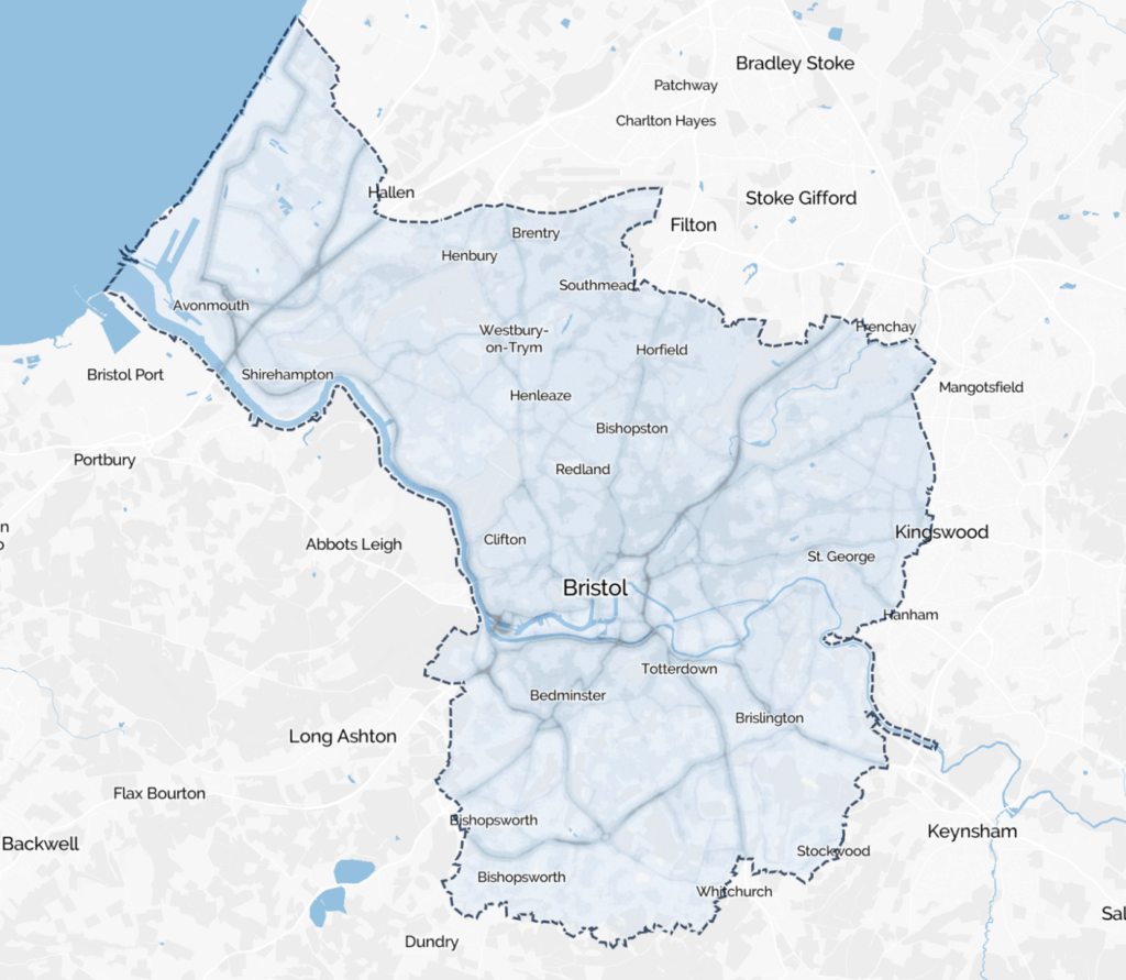
We’ve deployed AI-based air quality modelling in Bristol and Southampton, with our latest Airmap for Bristol (soon to be released) using the new CNN model. These cities didn’t previously have recent dispersion models to inform transport decisions and healthier routing alternatives for the public. Council officers and the public can now access the data in a thought-provoking and engaging way.
Now, we’re ready to scale nationwide with an affordable way to get air quality information and empowering tools to the people!
For Local Authorities: Imagine having street-level air quality intelligence that can:
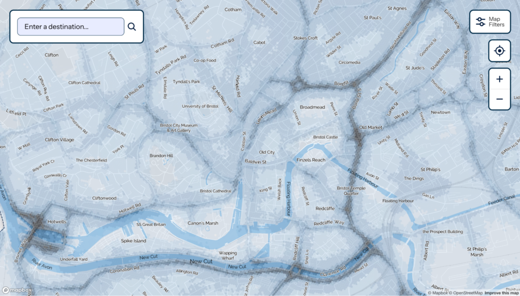
- Engage residents with dynamic, interactive air quality maps (see sotonairmap.com and soon-to-be-released Bristol Airmap) and provide optimised routing through cleaner air, greener and quieter corridors.
- Inform Active Travel infrastructure decisions by mapping the quality of the street network against the principles of the Healthy Streets approach.
- Support Air Quality Mitigation measures, planning and public support by providing clear, visually engaging information on how air pollution affects people’s daily lives.
What’s Next?
We’re launching our CNN-powered Airmap product, starting with Bristol. But the real opportunity is bigger: making air quality democracy the norm, not the exception.
Here’s how to join the conversation:
- Local authorities: Ready to give your residents the air quality information they deserve? The first 10 local authorities that get in touch (DM or via grant@tranquilcity.co.uk) will receive a free air quality model visualisation for a ward in your city to showcase the new model!
- AI researchers: What other “LLM problems” are actually perfect for small, focused models?
- Environmental professionals: How might tiny, specialised AI models transform your field?
- Big Tech: How might high-resolution air quality information be used in mass-market applications such as Google Maps, Citymapper, Rightmove or Trainline?
Want to bring street-level air quality intelligence to your city? Let’s talk: grant@tranquilcity.co.uk
#AirQuality #AI #MachineLearning #PublicHealth #SmartCities #OpenData #LocalGovernment #EnvironmentalJustice #Sustainability