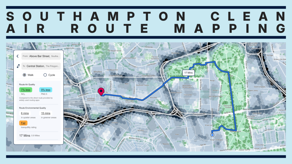
Last year we created the Airmap, a free-to-use web app that helps people find healthier, greener and more appealing active travel routes. It was first launched in Southampton as part of Southampton City Council’s Clean Air programme and funded via the Defra Air Quality Grant. Its creation was a partnership between Go Jauntly and the University of Southampton.
Encouraging more walking, cycling and wheeling for short urban journeys not only reduces emissions but also reduces people’s exposure to air pollution compared to travelling by car. This helps Local Authorities reduce people’s exposure to harmful air pollution, as well as promote healthier lifestyles that can boost public health and wellbeing.
But a key question we have been asked since the launch of the Airmap is “How does the time of my journey affect the amount of pollution I’m exposed to?”. Could travelling at off-peak times promote a further reduction in people’s exposure? What day of the week is best to choose to go into the office? Is walking in winter better or worse than walking in summer?
An update that displays variations of pollution throughout the day, week and season
We’ve implemented a brand new feature of the Airmap that accounts for the level of pollution at the time when a user is planning a journey. It gives users access to up-to-date information on the pollution levels of any location or journey, down to the nearest 20 meters. We’re excited to share with you how we did it.
Enhancing our air quality modelling with hourly air pollution data
We used our existing annual average air pollution model for Southampton and adjusted the results for different times using data from the Automatic Air Quality monitoring stations available in the city. These stations record hourly pollutant concentrations.
For each station, we analysed the data to understand the variation in nitrogen dioxide (NO2) and Particulate Matter (PM2.5) concentrations throughout the day (AM Peak, Inter-peak, PM Peak, night), across the week (weekday, Saturday, Sunday), and between seasons (Winter, Spring, Summer, Autumn).
Based on the modelled data point at each monitoring station, we calculated an adjustment factor that can be applied to uplift or reduce the pollution level based on the hourly, daily, and seasonal variation. This enables us to provide users with pollutant information relevant to the time they want to travel.
So, what did we find? How do time, day and season affect pollution exposure on active travel routes? The results are telling…
The time of day, week and season can significantly affect our exposure to pollution
Based on hourly data for 2023, we found the following insights:
- The least polluted day to commute during peak hours is Monday. There were 23% lower PM2.5 levels and 10% lower NO2 levels on average than the highest polluted day. It looks like Monday is the day when people are working from home!
- If you can commute outside of peak hours, when roads are less congested (10:00-16:00), this can further reduce pollution exposure by up to 24% for NO2 levels and up to 12% for PM2.5 levels.
- If you’re planning a weekend walk or bike ride, the least polluted time to travel is Sunday morning (07:00-10:00) with up to 39% less NO2 pollution or Saturday late morning to afternoon (10:00-16:00) with up to 24% less PM2.5 pollution.
- Summer is the least polluted time of the year with 42% less NO2 and 26% less PM2.5 than during Winter.
- Interestingly, PM2.5 levels were higher at night than in some peak periods (up to 23% higher), particularly during winter. We expect this is due to home heating (including wood burning).
What this means in terms of exposure/impact on residents
This means that with a bit of planning (and the Soton Airmap), people can meaningfully reduce their exposure to air pollution by making small changes. Helping people to make decisions like these, alongside the ongoing work of Southampton City Council to reduce air pollution, will mean that people breathe less pollution. Southampton will be a healthier city!
The Airmap tool can be used to demonstrate how Local Authorities are helping to reduce people’s exposure to air pollution and increase opportunities to connect to more natural environments.
Get in touch about how we can create one for your town or city by contacting Grant at grant@tranquilcity.co.uk